
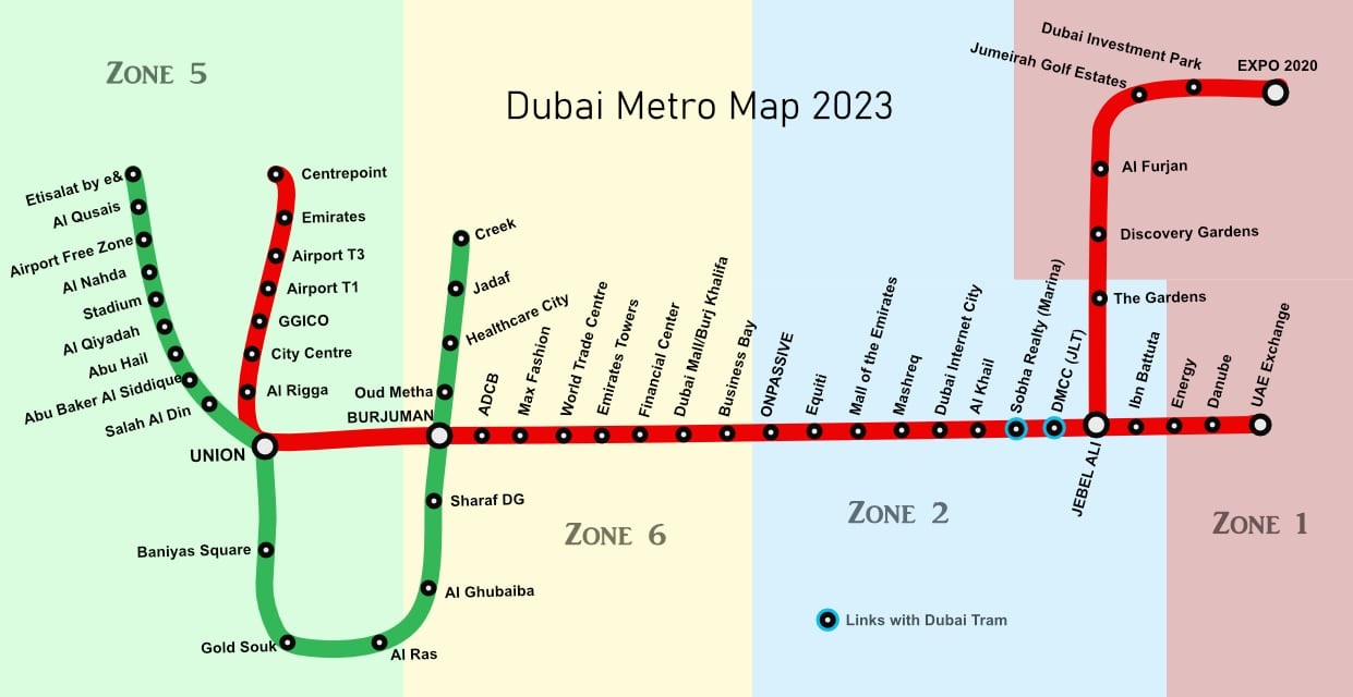
Dubai Metro Map with zones - Nearest Metro Station with map
The Dubai Metro, inaugurated in 2009, is a state-of-the-art urban rail system in the United Arab Emirates. This comprehensive transport system includes two lines - the Red Line and the Green Line, which combined, span over 74 stations across the city. The Dubai Metro is world-renowned for its exceptional punctuality, safety, and modernity, connecting different neighborhoods and points of interest throughout Dubai. This guide will offer a detailed overview of the Dubai Metro Map, breaking it down into distinct zones to help you navigate through this global city.
The line runs from Etisalat Metro Station in Al Qusais to Creek Metro Station, passing through the densely populated areas. Nearest Metro Station in Dubai.
Index of contents
The Red Line
Starting at the UAE Exchange, the Red Line runs all the way through to Rashidiya, connecting significant areas such as the Dubai International Airport, Business Bay, and Burj Khalifa/Dubai Mall along the way. There are approximately 29 stations on the Red Line, each providing easy access to nearby landmarks.
The Green Line
The Green Line operates primarily within the city center, running from Etisalat to Creek. Key stops along this line include the Al Qusais, Deira City Centre, and Al Jaddaf. The Green Line has around 20 stations and intersects the Red Line at Union and BurJuman stations, thereby creating a well-connected metro network.
Dubai Metro Zones - Nearest Metro Station
For ticketing and fare calculation, the Dubai Metro system is divided into seven zones. Here's a breakdown of these zones:
Zone 1: Covers the central part of Dubai, including areas like Deira and Bur Dubai. Notable stations in this zone include Union, BurJuman, and Al Ghubaiba.
Zone 2: This zone stretches towards the north-eastern part of the city, including areas like Al Qusais and Muhaisnah. The significant stations in this zone are Stadium, Al Nahda, and Rashidiya.
Zone 3: Encompasses areas such as Al Quoz, Business Bay, and Downtown Dubai. Key stations here include Noor Bank, Business Bay, and Burj Khalifa/Dubai Mall.
Zone 4: Includes the Marina and JLT regions. Some of the primary stations are DMCC, DAMAC Properties, and Ibn Battuta.
Zone 5: This zone covers the southern part of Dubai, including areas such as Jebel Ali. Key stations in this area are Energy, Danube, and UAE Exchange.
Zone 6: Zone 6 includes Dubai's outlying areas like Al Rashidiya and International City. Stations in this zone include Rashidiya and International City Dragon Mart.
Zone 7: This zone includes the peripheral areas, for instance, the zones towards the border of Abu Dhabi. It is less frequently traveled by daily commuters.
Download Dubai Metro Map
You can download the Dubai Metro map in PDF at the following link:
https://uaeidcard.com/Dubai-metro-map.pdf
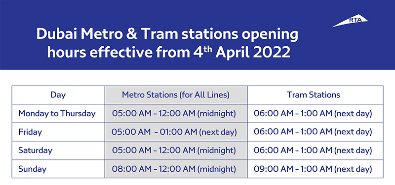
Dubai Metro Opening Hours For All Stations
Understanding these zones is important when using the Dubai Metro because ticket prices are determined based on the number of zones crossed during a journey.
The Dubai Metro system is efficient, clean, and easy-to-use. Along with its comfortable and air-conditioned trains, it offers a fantastic view of the city’s skyline and landmarks. Whether you're a tourist eager to explore Dubai or a local resident commuting daily, understanding the Dubai Metro Map and its zoning system will significantly ease your travel across this dynamic city.
More info:
https://www.rta.ae/wps/portal/rta/ae/public-transport/metro/about-metro/
https://www.rta.ae/wps/portal/rta/ae/public-transport/journeyplanner
https://www.rta.ae/wps/portal/rta/ae/public-transport/timetable#DubaiMetro
Rolla Mall Sharjah: Exploring a Shopper's Paradise

Who called me from this Number UAE?

Tattoo Shops near me in Dubai
How to get Certificate of Continuity in UAE online free

How to Obtain Your UAE Labour Card Number (Work Permit Number) Online

NOL Card Balance check online in 2024

How To Deactivate Du Daily Data Package 2 AED?

How to Check Immigration BAN in UAE?
Leave a Reply
More articles